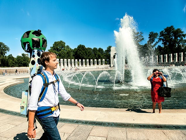
Forty pounds of Google-branded steel and circuits are strapped to my back. I’m scaling the tricky grass steps of the World War II Memorial on the Mall, the blades still damp from yesterday’s mid-August torrent of rain. Bewildered tourists jump in front of me to snap photos of this strange sight, their flashes at full.
Please, I think as nervous Google publicists monitor my precarious ascent, Do. Not. Fall.
This shouldn’t be so difficult. But when a potentially world-changing piece of technology is hanging on your not-very-sturdy frame, you can never be too careful.
That technology is the Google Trekker, and it represents the omnipresent company’s attempt to map the known world—or at least the parts it hasn’t already.
You probably already use Google Street View, the function on the Maps app that gives you a 360-degree panorama of most of the roads and intersections you’ll ever travel. Google started that program in 2007 by mounting some cameras and a GPS device onto a van and driving it around. A couple of years later and voilà, you can skip down the Champs-Élysées with a few clicks of a mouse. The cars are such a pop-culture phenomenon that they recently made a cameo on Arrested Development, in which the Michael Bluth character inexplicably drove one as his main vehicle.
But what about the places where you can’t drive? What about the Grand Canyon, the canals of Venice, and yes, the Mall? The Trekker takes the concept of Street View off-road, using a backpack camera system to photograph and map everything from remote hideaways to tourist traps.
That’s how I got myself into all this.
• • •
“We’re all a bit frustrated when you get to where the road ends,” says Steve Silverman, a technical-program manager at Google who led the group that built Trekker. “There’s a lot of world to cover.”
Silverman has experience mapping the unknown. Before coming to Google, he built cameras for NASA that were sent to Mars. The two tasks, he says, were remarkably similar: “Like Mars, we have to put Trekkers into very hard environments. It’s had to survive the summer heat at the bottom of the Grand Canyon and the winter temperatures at the top of Mount Fuji. Nobody else builds anything like this.”
The Grand Canyon expedition last fall was the Trekker’s first. Since then, it’s been to the Galápagos Islands, the wilds of New Zealand, the Canadian Arctic, an abandoned coal-mining island in Japan, and many more places. This summer, it was the Mall’s turn.
But why? Why go to such lengths to capture the endless snowy white of Iqaluit, Nunavut (“Canada’s coolest Arctic city!” according to its website), when most people can’t even find it on a map? The reasons range from utilitarian (“It will help people plan their trips,” Silverman says) to evangelical (“We want to bring the world closer to everybody”). But for a company like Google, maybe it’s also something a little simpler—to prove that it can.
• • •
The Ultimate Backpack
Google Trekker is 40 pounds of cutting-edge technology
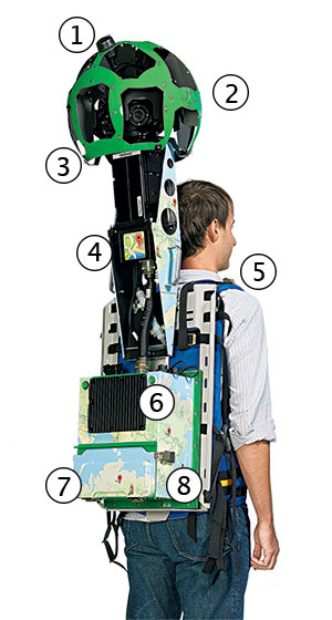
1. One of two GPS receiver antennas
2. 15 five-megapixel cameras
3. Accelerometer, gyros, magnetometer, and barometer
4. Ethernet and power-cable interface
5. Custom-made backpack designed by Google to fit a variety of body types
6. “Heatsink” cooling component for CPU
7. Two lithium-ion batteries designed to last a full day
8. 256-gigabyte solid-state hard drive that can store six hours of mapping data
Photograph by Jeff Elkins.
The tech behind Trekker can attest to that. The green orb on top has 15 five-megapixel cameras that take pictures every two seconds. Two GPS sensors peg the photos to specific coordinates, but in places like the bottom of the Grand Canyon where GPS isn’t as reliable, it also uses accelerometers, gyros, and magnetometers to orientate itself, plus a barometer for elevation. All the data is stored in an onboard hard drive and powered by two batteries that can last through a day of shooting. Once the “Trek” is finished, the raw images are transferred to a data center where computer magic shapes them into a final product. Software smooths out the bounce of the carrier’s walk and adjusts for height. Faces and license plates are automatically blurred out. The images are stitched into a cohesive panorama, and differences in color and intensity are matched.
The gadget backpack—one of several making their way around the world—is usually carried by a member of Google’s Street View team. Silverman himself took one down the Grand Canyon, Trekking for about two to four hours at a time. The plan is for these collections teams to cover the planet gradually from top to bottom. “We’re starting with the big places like World Heritage Sites,” Silverman says. “Then we’ll filter down to sites of national importance in different regions, then it will gradually move down to more local levels.”
To cover as much ground as possible, Google recently started lending the Trekker to third parties such as tourism boards, nonprofits, and government agencies. Presumably, the local experts will know the terrain better and be able to share their vision of whatever place they represent. “Tell us what makes this place amazing,” the form asks applicants about their potential Trek.
It’s spooky how easily the names of Google’s products can become verbs—as if they’re ways of life, things you do rather than objects you use. That’s how “to Google” found its way into Merriam-Webster, and Trekker is no different. I was going to be Trekking the Mall as Google employees talked to me about the time they Trekked Mount Everest. Soon you might be on your own computer, Gchatting your friends as you Trek New Zealand.
• • •
The morning of my Trek, I sat down at my computer and opened the browser. My homepage is, of course, Google. And coincidentally, that day there was a little blue line of text below the search bar in the section usually reserved for the company’s signature minimalist white space.
“Experience the Arctic and the Amazon, without the jet lag,” it said. Then a hyperlink: “Trek with Google Maps.” I clicked and was taken to a page telling me, “Unleash your inner explorer.” There was a video detailing the Trekker project, complete with a boppy indie-pop soundtrack, along with a selection of already-Trekked locales I could venture to.
I clicked on the first: Burj Khalifa in Dubai, the tallest building in the world. I stepped into the shoes of a Trekker carrier mounted precariously in a window-washing basket outside the 80th floor. I dragged my mouse across the screen to see everything from the aquamarine pool beneath me to the vast expanses of gray desert on the horizon. It was stunning, although my fear of heights made me thankful I wasn’t taking on this Trekker assignment for Dubai-ian magazine.
Next, on the other side of the world and at a very different elevation, I walked through the Amazon basin. I got lost amid the endless green canopy without fear of snakes or bullet ants or malaria. Then I circled the space shuttle Endeavour, docked in the Kennedy Space Center, followed by Launch Pad 39A, where the shuttle was sent into space. Can a Mars Trek be far behind?
• • •
I’m a terrible tourist and had never been to the World War II Memorial, which I was scheduled to Trek that day. So I used Google Maps on my phone to find my way there. It was easy to find the Google team: three young people surrounding a big, colorful backpack contraption decorated with the company’s cartoonish map designs. They were already attracting the glances of passersby. “I’m ready to Trek,” I told them.
One of the Googlers hoisted the Trekker onto my back as I strapped in. He gave me some advice about keeping steady, which he knew from experience—he was a professional Trekker scheduled to map the rest of the Mall later that day in the August humidity. He was also wearing comfortable sneakers, shorts, and a T-shirt and looked much better prepared for this than your humble, sweaty reporter. I tightened the straps as far as they could go and set off. The first thing I noticed was the top-heaviness—that big sphere of cameras tended to create a disconcerting wobble that set off alarm bells in my head. This was when I had to plead with myself not to fall and break a presumably extremely expensive marvel of modern engineering. But I didn’t fall—not walking up those steps or walking back down them when I was told where I was actually supposed to go.
Immediately the tourists set upon me, as I’d been warned. Their cameras swiveled from the memorial’s elegant bas-reliefs to me, befuddled and barely upright. A scrum of fifth-graders encircled me, waving to the Trekker’s 15 cameras and asking me about it. Some of the polite ones raised their hands. All the while, more pictures snapped. I was uncomfortably aware of how many vacation albums I would soon appear in. Park police approached, asked a token question about photo permits, then proceeded to gawk and study the device. “Can it look straight up?” Yes. “Will our faces be in it?” No. “When can we see the pictures?” Not for a few months.
Something about the Trekker absorbed people. Despite being a heavy piece of machinery, it looked inviting—its bright colors inspired that very Google atmosphere of playfulness and curiosity. Strangers simply walked up, eager to learn about the project. How often does that happen to a sweaty man carrying a suspiciously oversize backpack?
I began to understand what Silverman meant when he said he wanted Trekker to bring the world closer to everyone. People wanted to know when the panoramas would be uploaded so they could Trek the Mall, even when they were standing right on it. It was the prospect of connection, of the unknown being explorable any second of the day. “Oh, great,” one woman said. “Now I can show my mom where we went this vacation!”
• • •
“I want to let schoolkids in France see the pyramids in Mexico,” Silverman told me. “I want to let my grandparents go visit the bottom of the Grand Canyon. To bring the wonders of the world to everybody.”
It’s an ambitious goal, and as I unclasped the Trekker’s straps, I couldn’t help but think of how big that world is when you have a 40-pound backpack weighing you down.
Even so, I had barely left the memorial’s grounds before I turned around to see the Trekker hoisted up once more, strapped tight to the sneaker-clad Googler, ready to keep exploring.
This article appears in the October 2013 issue of The Washingtonian.

Michael J. Gaynor has written about fake Navy SEALs, a town without cell phones, his Russian spy landlord, and many more weird and fascinating stories for the Washingtonian. He lives in DC, where his landlord is no longer a Russian spy.