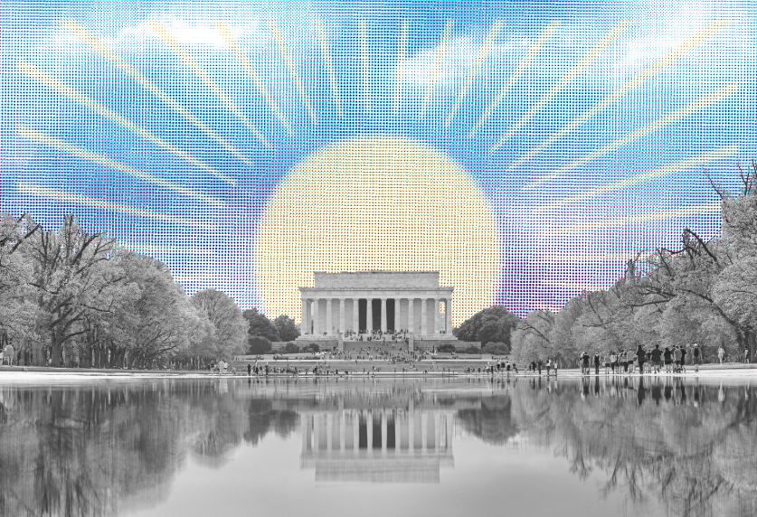
To drive into DC at sunrise over Arlington Memorial Bridge is like traveling through a postcard. Just ahead looms the neoclassical temple honoring Abraham Lincoln, the Great Emancipator, and beyond stands the towering obelisk to George Washington, who chose this site on the Potomac River as the nation’s capital. Visible in the distance is the dome of the Capitol, and beyond that the sky of the city, uncluttered by tall buildings, is streaked with orange and pink.
The bridge’s low banisters allow views up and down the river, empty at this hour except for a rower pulling at his oars. You can see other of Washington’s landmarks—the Kennedy Center and the National Cathedral on the left and the memorial to Thomas Jefferson on the right. But the views are fleeting: Traffic already is streaming across the bridge.
Memorial Bridge is DC’s grandest entrance, and it is dressed up with American patriotism and the suggestion that you are entering the capital of a world power. Eight-foot-high stone eagles are perched on pylons at the west end, and US flags are hung from every lamppost on special occasions. In spring, red tulips grace both ends.
It is obvious that care has been taken to make this a special place, imbued with beauty and symbolism. It is no accident that the bridge runs in a straight line from the Lincoln Memorial to the mansion of Confederate general Robert E. Lee on the hillside above Arlington National Cemetery. The bridge memorializes the reunification of the United States following the Civil War—linking in a span of 2,100 feet not only Lincoln and Lee but the capital of the Union with Virginia, the capital of the Confederacy.
Bridges are often seen as purely utilitarian—as prosaic as the roads at either end—and for good reason. They are indispensable in a metropolitan region that covers hundreds of square miles and is heavily dependent on cars and trucks. The Woodrow Wilson Memorial Bridge carries 200,000 vehicles a day—some 73 million a year—and will accommodate even more when the first of two new spans opens in June.
Bridges integrate the region. They turn natural barriers like rivers into afterthoughts, cutting travel times, ending social isolation, speeding the delivery of goods, even setting off real-estate booms. A century ago the first bridges across Rock Creek Park allowed people who worked downtown to live in the new suburban-style neighborhoods of Northwest DC, and construction of the first span of the Chesapeake Bay Bridge in 1952 made the Eastern Shore the capital’s summer playground.
Wartime offers reminders of the strategic importance of bridges. The main one across the Potomac was burned to prevent the British from marching into the capital during the War of 1812, but they came in by surprise from the east across a bridge on the Anacostia River and put a torch to the Capitol and White House. The bridges over the Potomac and Anacostia were heavily guarded by Union troops during the Civil War, and bridge traffic was so heavy during World War II that the military added pontoon bridges across both rivers.
The terrorist attack of September 11 has heightened bridge security. Last fall a suspicious car under the Francis Scott Key Bridge that sped away when approached by police set off an inspection of all bridges, and fear of a bomb in a car or truck prompted the abandonment of a planned parking lot under the west end of the new Wilson bridge.
While carrying traffic is the obvious function of bridges, it is surprising how many other uses we’ve found for them. Fishermen dangle their lines from bridges or maneuver their boats next to piers, especially near those that support the Chesapeake Bay Bridge, because that’s where fish tend to gather. Eagles and other raptors build nests under bridges, for protection and access to fish, and the artificial islands along the tunnel-bridge that runs across the bay from Norfolk to the Eastern Shore attract thousands of bird watchers. Every October, in southern West Virginia, people are allowed to parachute off the bridge over the New River Gorge; at 876 feet above the river it is the second highest bridge in the United States. Bridges serve bicyclists, runners, and ordinary pedestrians, including about 40,000 who walk more than four miles across the Chesapeake Bay Bridge each spring when one span is closed to traffic—an event that has been cancelled twice since September 11 partly for security concerns.
Bridges are useful for those with a statement to make, and not just practitioners of graffiti. Peace activists marched across Memorial Bridge by the thousands in 1967 en route to the Pentagon to protest the war in Vietnam. Every Memorial Day veterans of that war roar across the same bridge on their motorcycles to pay respect to the fallen at the Vietnam Veterans Memorial.
Bridges are handy for making civic statements. Washington has three bridges named after presidents: Theodore Roosevelt, William Howard Taft, and Woodrow Wilson. Three others are named in honor of African-Americans: abolitionist orator Frederick Douglass, National Urban League president Whitney Young, and bandleader/composer Duke Ellington. Their names were added to existing bridges in the wake of the civil-rights movement. Three of Washington’s bridges memorialize people who became famous through music: Ellington, the jazz legend who was born here; John Philip Sousa, who was director of the United States Marine Band and a composer of stirring march music; and Francis Scott Key, who wrote the lyrics to “The Star-Spangled Banner” and once lived in Georgetown near the bridge that bears his name.
Some of the city’s best views are from bridges—the spires of Georgetown University from the Key, the treetops of Rock Creek Park from the Taft, and Robert F. Kennedy Memorial Stadium from the Whitney Young. The best bridges are like giant sculptures that are often most picturesque when seen from below—one reason that the Key, the Memorial, and the Taft are favorites of photographers.
Bridges are fixed on the landscape in a way that they become part of a city’s collective geographic consciousness. They are landmarks we all know, helping traffic reporters make sense of rush-hour commutes and giving passengers a sense of how soon they will land at Reagan National. They are capable too of evoking memory—of the 1982 crash of an ice-covered Air Florida jet into the 14th Street bridge or of John F. Kennedy’s funeral cortege moving slowly across Memorial Bridge in 1963 on its way to the eternal flame.
Cities often draw some of their identity from bridges, a few of which have become big tourist attractions. It is hard to imagine London without the Tower Bridge, Florence without the Ponte Vecchio, San Francisco without the Golden Gate, or New York City without the Brooklyn Bridge, the George Washington, or the Verranzano-Narrows. New York has bragging rights in having eight of the world’s 100 longest suspension bridges, though Pittsburgh, where the Allegheny and Monongahela rivers converge to form the Ohio, has more bridges per capita than any American city.
Bridges also have a somber side. Several people every year jump to their deaths from Washington’s highest bridges, though exact numbers are hard to come by. In the mid-1980s, a spate of suicides from the Duke Ellington and William Howard Taft bridges, which run high above Rock Creek Park, promoted installation of a suicide fence on the Ellington. On the Anacostia, one span of the 11th Street bridge is named in honor of a DC police officer, Kevin Welsh, who drowned while trying to save a woman who had jumped.
The bridges that get the most attention in Washington go across Rock Creek Park and its two big rivers, the Potomac and Anacostia. There are seven major bridges across the Potomac, five clustered in the center of DC and two on the Beltway. There are six major bridges across the Anacostia and more than a dozen bridges scattered along the length of Rock Creek Park.
But there are lots of others. Virginia has about 12,700 bridges and Maryland nearly 5,000—a fair share of them in the Washington suburbs—while DC has just over 200. We have dozens of bridges across small streams, from Bull Run to Sligo Creek, across the Tidal Basin, across the Chesapeake & Ohio Canal, across coves in lakes, and across valleys and gorges. Bridges are used to span sensitive wetlands, one of the features promised for the Intercounty Connector in Maryland. And many bridges carry streets and highways over other streets and highways, most spectacularly in the new Springfield Interchange. The region also has numerous railroad bridges, spans carrying Metro trains, and nice little bridges reserved for pedestrians and cyclists.
Washington’s well-traveled river bridges lack the scale and drama of bridges in some other places. We have none that stretch on for miles, like the one in New Orleans across Lake Pontchartrain (38 miles) or the string of 37 bridges across the Florida Keys (113 miles). We have no towering suspension bridges, like the Golden Gate, the one connecting the upper and lower peninsulas of Michigan across the Straits of Mackinac, or the one across the Delaware River at Wilmington.
Washington’s bridges tend to be low-profile, like the skyline of the city. “They are subtle and elegant and don’t scream at you,” says Eric DeLony, retired chief of the National Park Service’s Historic American Engineering Record and author of Landmark American Bridges. Several are distinguished—blending natural setting, engineering, and architecture into structures worth contemplating as well as crossing.
Crossing the River
Washington’s dominant natural feature has always been the Potomac, from the moment this area was chosen in 1790 to become the site of the nation’s capital. Georgetown and Alexandria, both included in DC’s original boundaries, had grown up hugging the river’s banks, dependent on it for their life. The river was both a blessing and a curse—a watery highway where boats could move goods and people but an impediment to overland travel that had to be crossed by boat. The river assured that Washington, as technology advanced, would become a city of bridges.
In the beginning—at a time when people walked, rode horses, or kept teams to pull wagons and carriages—getting across the region’s rivers and creeks had to be accomplished without bridges. Creekbeds where the water was shallow and the banks were sloped became fording spots—all of them useless after a rainstorm. The Potomac and Anacostia were traversed by ferries. The Potomac alone once had 100 ferries, but only White’s Ferry, which carries vehicles across the river north of Leesburg, still operates.
The area’s first bridge, linking Georgetown with land to the east, was built over Rock Creek at M Street in 1788—two years before the decision to put the capital here. A second bridge, at K Street, followed in 1792; decorated with the names of the original 13 states, it was the first to emphasize the city’s national importance. It also was the bridge that President John Adams crossed on June 4, 1800, when the capital was officially moved here from Philadelphia.
The first bridge over the Potomac was a few miles upstream from Georgetown, where the river was narrow enough to be spanned by the rudimentary bridge-building techniques of the day. Built in 1797, it was the first of eight bridges that have occupied this site, known for most of its history as Chain Bridge. The name comes from the third bridge there, built in 1810, which was suspended from two wrought-iron chains. The modern bridge, which dates from 1937, sits atop piers of a predecessor bridge built in the 1870s.
Today’s 14th Street bridge also stands at an old Potomac crossing, where the first bridge was built in 1809. It was called the Long Bridge and ran for nearly a mile over piles of rock, mud flats, causeways, and drawspans that cut travel time from the Capitol to Alexandria. Only a few years later, when British troops invaded the city during the War of 1812, President James Madison fled into Virginia as flames engulfed the city behind him, and the drawspan on the Virginia side was burned to prevent a British pursuit. By 1818, the bridge was back in business.
There also were bridges across the Anacostia by the early 19th century to allow people and goods to move into the capital from the Maryland countryside—all on the same sites as modern bridges. The earliest, built in 1800, was at Benning Road, and it was the one British troops crossed on their way into the city. Two other bridges, at Pennsylvania Avenue and at 11th Street, were constructed soon after. The 11th Street bridge was near the Navy Yard, then a thriving shipbuilding facility, allowing workers to live on the east side of the river in a place called Uniontown, which historians regard as Washington’s first “suburb.” This was the bridge used by John Wilkes Booth when he fled on horseback into Maryland after assassinating Abraham Lincoln.
While nearly all of today’s bridges are built and owned by governments, the city’s first bridges—like early turnpikes—were private enterprises. The government usually chartered a private company, which raised money by issuing stock, though occasionally there were individual owners; William Benning bought at a bankruptcy auction the bridge that bore his name.
To profit on their investment, they all charged tolls—Chain Bridge in the early 19th century charged 3 cents for a pedestrian, 8 cents for a person on a horse, 25 cents for two-wheeled vehicles, and 50 cents for four-wheel vehicles. The first free bridge built by the government was at the 14th Street site in 1835, according to Donald Myer, former assistant secretary of the Commission of Fine Arts, whose Bridges and the City of Washington is the authoritative work on the subject and the source for some of the historical material here.
Though a few early bridges were built of stone, the majority were made of wood. Some were covered to protect against the weather, in a style that was distinctly American and survives in a few rural areas of the country. There are still about 750 historic covered bridges in existence—Pennsylvania, with more than 200, has the most. The closest to Washington are the three in Maryland’s Frederick County.
Many of Washington’s wooden bridges did not last long. Some were poorly built to begin with. Wood rotted and was vulnerable to fire, sometimes from sparks thrown off by steamboats that plied the rivers in the 19th century. Wooden railroad bridges were especially vulnerable to sparks from locomotives.
Floods and ice were the biggest threats, particularly because Washington’s bridges were not that high off the water. The M Street bridge of 1788 collapsed in a storm a few years after it was built, taking with it a carriage and four horses, all of which drowned; ever after believers in ghosts claimed they could hear frantic equine screams when the creek flooded. The problem was chronic—Donald Myer says bridges at the 14th Street crossing were damaged by high water and ice seven times from 1836 to 1887. Ice built up against the low bridges, sweeping them away or turning them into dams; in 1889 an ice dam at the bridge at 14th Street flooded the Mall.
After the Civil War, wood lost dominance, and the “iron truss” bridge became standard. No iron-truss bridge survives in Washington, though there’s one from 1850 in Savage, Maryland, off Interstate 95—originally built for the railroad.
Nineteenth-century Washington also had a string of bridges that were part of the Chesapeake & Ohio Canal, begun in the 1830s to carry coal, wheat, and other commodities between Georgetown and Cumberland, Maryland. They were unusual because they were troughlike aqueducts that carried the canal over the rivers and creeks along its 185-mile route, creating the odd scene of barges moving along above the natural waterways below. There were 11 in all, one of the most beautiful being the recently restored multiple-arch gem over the Monocacy River in Frederick County.
A similar structure, known as the Aqueduct Bridge, ran from Georgetown to the Virginia shore where Rosslyn now stands. Finished in 1843, it carried barges on an extension of the canal that ran down to Alexandria to keep that city competitive with Georgetown as a trading center. It was torn down after completion of the Key Bridge in the 1920s.
Another historic bridge with a distinctive function is the Cabin John Bridge in Montgomery County. Not to be confused with the nearby American Legion Bridge on the Beltway, the Cabin John was begun in 1853 as part of the DC water-supply system that remains in use to this day. Montgomery Meigs, a captain in the Army Corps of Engineers, conceived the project, which brought Potomac River water through a giant underground conduit from just above Great Falls into a reservoir in Georgetown 12 miles away. The Cabin John Bridge carried the water 80 feet over Cabin John Creek in a brick-lined pipe nine feet in diameter, encased in an single-arch stone bridge that now also traverses the Clara Barton Parkway. A single-lane section of MacArthur Boulevard runs atop the bridge, which many people pass over with no idea that a river of water is rushing through the pipe below.
Work on the Cabin John was halted at the outset of the Civil War but soon resumed and was finished in 1863. At the time it was the world’s longest single-span stone masonry bridge and even now remains second only to a bridge in Europe. Its antique stonework and impressive height make it one of Washington’s most impressive spans.
It was an object of wartime animosity. Jefferson Davis was secretary of War when construction began, but his defection to become president of the Confederacy prompted a decision to give him no credit on the commemorative plaque. Forty-five years later, President Theodore Roosevelt ordered Davis’s name included.
Coming of the Car
Shortly after the beginning of the 20th century, a tally of the traffic across a new bridge over the Potomac at 14th Street offered a peek into the future. The daily averages for 1908, according to Donald Myer, showed 780 double teams of horses, 369 single teams, 9 equestrians, 543 pedestrians, and 253 electric trolleys. Scattered among these old forms of transportation were 103 automobiles, which had been introduced in Washington a decade earlier. The new bridge, with uncanny prescience, was called the Highway Bridge.
As cars and trucks gained dominance—there were 56,000 here by 1920—Washington experienced a new round of bridge building. On the Potomac the first new bridge was the Francis Scott Key, which was built alongside the old Aqueduct Bridge and completed in 1925. The concrete structure, which has multiple arches 72 feet above the water, is one of the city’s most handsome spans. The clumsy Whitehurst Freeway was added on the Georgetown end in 1949.
The next Potomac bridge was the Arlington Memorial, completed in 1932, a century after first proposed by President Andrew Jackson. Designed by the New York architectural firm McKim, Mead & White, it is a masterpiece of proportion with nine neoclassical arches, gray granite facing, and monumental sculptures at either end. It has a steel drawbridge that most people never notice because it repeats the decorative scheme of the stone-faced spans and is painted to match.
Memorial Bridge, more than any other, is designed to mesh with the design created for the city in the 1790s by Pierre Charles L’Enfant. The Frenchman’s plan contemplated only one Potomac bridge—just above Georgetown—and his plan for a street grid crosscut by broad avenues remained incomplete in the 19th century. But interest in restoring L’Enfant’s vision was aroused in 1901, with the rise of the City Beautiful movement and creation of the McMillan Commission, which sought to revitalize Washington’s monumental core. The commission spurred the removal of railroad tracks from the Mall and the creation of Union Station, the Lincoln Memorial, and Memorial Bridge. Much dredging, rechanneling, and land filling were required to get the bridge and the Lincoln Memorial in just the right spot.
The alignment of new bridges with the streets and avenues of the L’Enfant plan has always been an issue. Though Memorial Bridge runs at an angle from the Mall to Lee’s mansion, it still manages to extend L’Enfant’s idea into Virginia. Rock Creek’s bridges follow the plan, including those that carry Connecticut and Massachusetts avenues, and so do most of the Anacostia bridges, especially the Whitney Young, which carries East Capitol Street, one of the streets that define the city’s quadrants. But other bridges pay L’Enfant no homage, including the 14th Street, the Roosevelt, and the Key, which ends in Georgetown at Dixie Liquor.
The increase in car and truck traffic also required new bridges on the Anacostia before and after World War II—most replacing older structures. The first was a new bridge carrying Benning Road in 1934, followed by a Pennsylvania Avenue bridge (named for John Philip Sousa) in 1942, a South Capitol Street bridge (later named for Frederick Douglass) in 1950, an East Capitol Street bridge (now named for Whitney Young) in 1955, and an 11th Street bridge at the Navy Yard in the mid-1960s. A new Benning Bridge was built in 2002, and a stately replacement for the old, unattractive Douglass is in the planning stages, as is a replacement for the 11th Street bridge.
Rock Creek, which ripples for miles through the heart of Northwest DC, was such a barrier to transportation that someone in the late 19th century suggested filling the surrounding valley with dirt. A better idea, which came to pass in 1890, was to turn it into a public park—a wilder version of New York’s Central Park. The park’s tree-covered ravines necessitated a spate of bridges, some that soar dramatically over the Rock Creek and Potomac Parkway and others that are modest. The Pebble Dash Bridge and Boulder Bridge, small arched spans built in 1902 with rustic stonework, are among Washington’s most romantic.
Rock Creek’s first bridges were built by real-estate speculators, who saw land west of the park and in suburban Maryland as logical places to build new homes for Washington’s professional class. Such bridges crossed the valley at Connecticut Avenue, Massachusetts Avenue, and Calvert Street, serving vehicles and streetcars. The most elaborate private project was conceived by Francis Newlands, a congressman and senator from Nevada. In the 1890s Newlands bought land to extend Connecticut Avenue north from downtown, built two bridges across Rock Creek, laid miles of streetcar tracks, created a country club, and put in an amusement park at the end of the line—all to sell lots in a real-estate development he called Chevy Chase Village.
The first of the Rock Creek bridges still in use carries Connecticut Avenue. It was completed in 1907 and named in 1931 for President William Howard Taft, who lived nearby and used to stroll across it. It was designed by an engineer named George Morison, a specialist in railroad bridges. Morison created one of the nation’s largest bridges built of concrete without steel reinforcement, though its $1-million price tag was considered scandalous.
Morison also set a stylistic precedent for Washington bridges. While John A. Roebling’s Brooklyn Bridge of 1883 hung from towers featuring Gothic arches, Morison designed the Taft bridge with seven arches like those the Romans favored in their aqueducts. The effect was dramatic, especially as the topography required a bridge that ran 125 feet above the valley. The arches also fit the neoclassical preference that until recently dominated the city’s official architecture, from the Capitol and the Lincoln Memorial to the original building of the National Gallery of Art. The Taft also features large lion sculptures at either end, which were restored a few years ago to great acclaim and are the reason many people ignore the official name and call this “the Lion Bridge.”
This same disregard applies to the bridge over Rock Creek at Q Street, known properly as the Dumbarton Bridge but colloquially as “the Buffalo Bridge.” With two large sculptures of American bison at each end, this bridge, built in 1915 when bison had been hunted to near extinction, is one of Washington’s most decorative. Its arches are Roman, five in all, but the decoration is purely American. Besides the bison up top, the bridge features on its sides 56 identical sculptures of the head of a Sioux chief named Kicking Bear, who had been at the Battle of Little Big Horn and later toured with Buffalo Bill Cody’s Wild West show. It’s also one of the few Washington bridges built on a slight curve.
Once established, the Roman arch was irresistible to the bridge designers of Rock Creek. The Calvert Street bridge, completed in 1935 and renamed in 1974 for Duke Ellington, has three arches. And the Massachusetts Avenue Bridge, finished in the early 1940s, has a single arch 75 feet high.
Our Ugliest Bridges
The interstate-highway system, authorized by Congress in 1956 and paid for mostly by gasoline taxes, set off a national boom in road building with bridges to match. Interstates now stretch across 43,000 miles and include about 55,000 bridges over the deepest canyons, widest rivers, and every other spanable space imaginable. The system’s limited-access design also meant that every crossroad between exits required a new bridge over the interstate itself.
About 300 miles of interstate, with dozens of bridges, were built in the Washington area. Interstate bridges were built exclusively for cars and trucks, with an emphasis on maintaining a continuous flow of traffic at high speeds. They had long approaches with no superstructure, which meant a driver got across a bridge almost without noticing. Compared with some of Washington’s older bridges, they were simple in design—concrete piers, steel girders, a roadway—and devoid of style.
The Beltway, the 64-mile interstate that encircles the core of the region, required bridges across the Potomac in two new locations. Northwest of DC was the American Legion Memorial Bridge—completed in 1962—which offered motorists a view of a stretch of the tree-lined river gorge. To the south, where the river ran nearly a mile wide, was the Woodrow Wilson Memorial Bridge, which was finished in 1961 and provided views of the Washington Monument and Capitol. The Wilson, which had one of the few drawspans in the interstate system, was Washington’s longest (5,897 feet) and most expensive bridge, costing nearly $15 million (about $91 million in today’s dollars). President Wilson’s widow was slated to be an honored guest at its dedication, but she died the night before.
Both bridges were unimaginative—the Wilson, says Duke University bridge expert Henry Petroski, “doesn’t even deserve the term ugly.” But they became packed with traffic far beyond projections.
Some of it was generated by the decadeslong real-estate boom that the Beltway triggered. Washington’s suburbs were mostly inside the Beltway at the time, but the two bridges, which provided the first close-in link between Maryland and Virginia, changed all that. In the 30 years after creation of the Beltway, Fairfax County’s population grew from 261,000 to 819,000, Montgomery’s from 341,000 to 757,000, Prince George’s from 357,000 to 729,000—and nearly everybody had a car or two.
Some of the traffic on the Wilson bridge also derived from an unexpected change in highway-construction plans in the mid-1960s. Interstate 95, which was slated to run through the heart of DC and carry some long-haul traffic, was canceled in the face of antifreeway protests. That meant thousands of cars and trucks passing through Washington on I-95 were forced to go around the eastern side of the Beltway (I-495) and cross the Wilson bridge.
Though most inner-city freeways were canceled, enough got built to give the core of the region several interstate-style bridges.
On the Anacostia, the twin-span 11th Street bridge, completed in the late 1960s, connected the Southeast Expressway (I-395) to the Anacostia Freeway (I-295) near the Navy Yard. Another Anacostia bridge, which would have connected I-395 and I-295 at Barney Circle near RFK stadium, was canceled about a decade ago in the face of objections from the neighborhood and environmentalists.
On the Potomac, the 14th Street bridge carried I-395 from Virginia to hook up with the Southwest Expressway. Actually, the bridge consists of three spans—one (built in 1968) named for Rochambeau, a French general who fought for the American colonies in the Revolutionary War; one (1960) named for George Mason, the Virginian known as the Father of the Bill of Rights; and one (1950) that was named later for Arland D. Williams Jr., who died in the Air Florida plane crash. Nearby is a railroad bridge and another that serves Metro trains, making this the most crowded crossing on the river.
Theodore Roosevelt Memorial Bridge, which carries I-66 into DC just south of the Kennedy Center, was built in the early 1960s, but not without objections. The Commission of Fine Arts and the National Park Service opposed it, thinking it was an intrusion on the Mall, the Lincoln Memorial, Arlington Cemetery, and the Potomac shoreline. Some suggested a tunnel, and conservationists pointed out the irony of building a big bridge across the southern tip of an undeveloped island that had been set aside as a natural sanctuary to honor Roosevelt, one of the country’s great conservationists.
Protests in the 1960s, part of the larger fight against inner-city freeways, did stop one Potomac bridge. It would have been about half a mile north of the Key and was to be called the Three Sisters Bridge, after the three rock outcroppings visible there in the middle of the river. Designed to carry a spur of I-66 from Arlington into DC, where it would have hooked up with a new freeway, the first stage of construction on the bridge began in the late 1960s. But it was halted by the antifreeway movement, which included a 1969 occupation of the little islands by banner-carrying college students, 141 of them arrested after a bloody confrontation with police.
There was one irony: This was the one place on the Potomac where Pierre L’Enfant, nearly two centuries before, had sketched a bridge into his plan.
Rebuilding the Wilson
No Washington bridge has received more complaints during the past decade than the jam-packed, deteriorating Woodrow Wilson. Opened in 1961 to serve 75,000 cars and trucks a day, it reached capacity within eight years and now carries 200,000. That’s slightly less than the American Legion and the 14th Street (both 220,000) and far less than the George Washington Bridge in New York (330,000), but it’s more than the Golden Gate (116,000).
The Wilson has long been a bottleneck, stemming mostly from the fact that the eight lanes of the Beltway narrow to six lanes on the bridge—a situation aggravated by an accident rate twice as high as at the American Legion, by drawspan openings, and by the occasional delay when some suicidal person threatens to jump. Because backups can stretch 20 miles or more, the American Automobile Association rates the Wilson one of the nation’s ten worst bottlenecks.
Another problem was that the Wilson bridge was designed to the weight standards of the 1950s, when allowable weights for trucks were lower. Thousands of heavy trucks thundered across the bridge—the number is now 22,000 a day—setting off vibrations that weakened its steel beams.
Efforts were made to patch up the Wilson, including a redecking in 1985, and there were suggestions that a weight limit might be imposed. But a consensus developed by the mid-1990s that it wasn’t cost-effective to maintain the bridge much longer.
Several alternatives were studied. A tunnel was twice as expensive as a bridge, would require banishment of trucks carrying hazardous materials, and would demand damaging excavation of the river bottom. A high-suspension bridge, with clearance for tall ships, would require a steep approach that would slow truck traffic, would loom over the nearby Old Town Alexandria waterfront, and would be on the flight path into Ronald Reagan Washington National Airport.
The final choice, made in 1996, was a new bridge with twin spans, just south of the existing bridge. The combined spans will have 12 lanes, six in each direction. The bridge is designed to carry 300,000 cars and trucks a day—that’s more than 100 million a year—and is supposed to last 75 years. One lane each way is reserved for mass transit, if Metro ever builds a Beltway line, though in the immediate future they will be used for HOV lanes, HOT lanes, or express buses.
Construction began on the new Wilson in 2000, and it is the costliest US transportation project now in progress. Total cost is estimated at just over $2.4 billion, nearly half of that for the bridge itself and the rest to rebuild two Maryland and two Virginia interchanges nearby and nearly eight miles of the Beltway. That compares with more than $14 billion spent on Boston’s money-eating “Big Dig,” an estimated $3 billion for Maryland’s proposed Intercounty Connector, and $700 million for the new Springfield Interchange. About $1.6 billion of the Wilson money comes from the federal government, with the rest from Maryland ($305 million), Virginia ($515 million), and DC ($16 million).
The Wilson project is such a big undertaking that it will require 11 years of construction—23 years from the time the first studies were initiated. The first span, which eventually will carry eastbound traffic on the Beltway’s outer loop, is to open this spring, and the westbound span on the inner loop in 2008—but the final interchange, at Telegraph Road on the Virginia side, won’t be finished until 2011. After the first span opens, the old bridge will be torn down, and there will be two-way traffic on the new span until the second span is completed.
Commuters on the old bridge have watched for years as the new bridge has taken shape—a noisy scene filled with trucks, barges, cranes, and hardhatted construction workers, as the project moved from dredging, pile driving, installing the piers, setting the steel girders, and laying the deck. “It’s been like redoing your living-room floor while you are having a party,” says John Undeland, the project’s spokesman.
About 145 barges moved 340,000 cubic yards of dredge material 170 miles to fill in a sand-and-gravel pit at Shirley Plantation on the James River, transforming it into a cornfield. A nine-story apartment house at Hunting Towers, three garden-apartment buildings, and a couple of office buildings were demolished to create space for new approaches on the Virginia side. The task is so big that it was broken into 32 contracts, five of them on the bridge itself. The project employs about 1,400 people.
In an effort to make the new bridge more attractive than the old one, the design was chosen in a competition—a process, as Henry Petroski points out, that is unusual in the bridge business. The specs demanded a bridge with “high aesthetic values” that took its cues from Washington’s monumental core, eight miles upriver. Also required was use of the arch as a motif, in keeping with other Potomac bridges such as the Memorial and the Key.
The winning design featured V-shape piers supporting slightly haunched deck girders—an arrangement that created faux arches. The selection judges were impressed. One said the piers would rise from the river as if Neptune’s hands are holding the bridge, and another likened them to seagulls taking flight. There will be 17 sets of these, far fewer than the 57 sets of perpendicular piers under the old bridge. They will rest on 1,400 piles—some as big as six feet in diameter and some driven 210 feet into the earth.
The Wilson project also underscored the political and bureaucratic complexities of large-scale public works, especially in a region where government authority is fragmented. The bridge connects two states and runs across a tip of DC, which required agreement among politicians and the transportation departments of all three jurisdictions. Virginia and Maryland share management of construction. But the federal government has been involved, too, with money appropriated by Congress and construction supervision by the Federal Highway Administration.
There’s also been input from the Army Corps of Engineers; the US Coast Guard, which oversees maritime traffic; the National Park Service; the US Fish & Wildlife Service; the National Capital Planning Commission; the Commission of Fine Arts, which monitors design in the federal enclave; the City of Alexandria; and Prince George’s and Fairfax counties.
The four decades between construction of the old Wilson bridge and the new also saw the rise of interest groups demanding a voice. No longer was it possible for highway departments to operate without citizen involvement. Motorists, drawbridge users, the trucking industry, historic preservationists, transit advocates, the disabled, labor unions, chambers of commerce, associations of nearby homeowners, users of an adjacent park, bicyclists—all had their own ideas. One result: While the old bridge was strictly for cars and trucks, the new one will have a safe, dedicated lane for bicyclists and pedestrians linked to trails at either end.
No force was more pervasive than environmentalism, which was barely on the radar when the first Wilson bridge was built, in three years, beginning in 1958. Groups like the Sierra Club, which led opposition to the new Wilson, were less visible and powerful then. The Environmental Protection Agency did not exist—it was created in 1970—and no “environmental impact statements” were required. Most highway engineers were strictly concrete-and-steel guys. One was quoted about filling in a “swamp” for an approach to the old Wilson—a natural feature we now call a “wetland.”
A result of all this is that about $100 million is being spent on making the new Wilson bridge more environmentally sensitive. The EPA and state environmental agencies mointor the project, and inspectors watch for spills of oil or concrete and stay attuned to the well-being of a pair of bald eagles that has nested nearby. Dredging was prohibited during spring and summer when it might damage fish and aquatic grasses, and “fish fences” were set up to keep them away from pressure waves created by driving piles.
The project also includes numerous “environmental mitigation” projects to compensate for unavoidable damage to nearby wetlands and aquatic grasses. At the east end of the bridge, 84 acres of land and water will become an eagle sanctuary, but much of the area around the bridge is so urbanized that other mitigation projects had to be shifted miles away to other parts of the Potomac watershed. Included are the creation of new wetlands, the planting of aquatic grasses, reforestation, shoreline stabilization, stream restoration, fish restocking, and the clearing of barriers in Rock Creek to allow passages of migratory fish.
Jones Point Park, which lies under the bridge’s west end, also will be reconfigured and upgraded. And there’s a proposal, pushed by a coalition of Chesapeake Bay watermen, to dump the debris from the old bridge into the bay to create an artificial reef as habitat for oysters and fish.
One of the more controversial decisions about the new bridge was to include a drawspan, specifically a “bascule” mechanism that raises like extended fingers to create clearance for passing vessels. Washington has never been a big port or industrial center, so the number of commercial freighters on the Potomac has always been limited. But the old Wilson included a drawspan—near the west end where the river is deepest. So did the Memorial and one of the three spans at 14th Street, though they have been sealed shut for three decades. The Roosevelt and two other spans at 14th Street were built without drawspans.
The debate over whether to include a drawspan on the new Wilson resulted from the fact that it was costly but likely to serve few users. Ceremonial tall ships, sailboats, yachts, and the occasional naval vessel or cruise ship had passed through the drawspan of the old bridge, but the biggest commercial user was the Washington Post, which brought freighters carrying newsprint from Canada and Scandinavia into its Robinson Terminal in Alexandria. All these required 260 openings a year, which some people argued was not enough to justify a drawspan. But the Post and other maritime interests successfully lobbied for a drawspan, which will cost just over $200 million. Because the new bridge has a 78-foot clearance—28 feet higher than the old—opening the drawspan will be required only 65 times a year, about 20 for the Post.
No More Bridges?
The Washington area has many big projects on its agenda for the next decade: the Intercounty Connector, Metro service to Dulles International Airport, a new baseball stadium for the Nationals, a cleanup of the Anacostia River and revitalization of its waterfront, restoration of the Chesapeake Bay. Though complicated, controversial, and costly, all these are possibilities. But one of the most contentious questions is whether to build another bridge across the Potomac as part of a new highway in the outer suburbs.
Two Potomac bridges already exist beyond the Beltway, at the far edges of the region. Thirty-five miles upriver from the American Legion stands the Point of Rocks Bridge, originally built in 1939 and replaced in 1980 to carry Route 15 between Loudoun County in Virginia and Frederick County in Maryland. About 35 miles downriver from the Wilson is the Governor Harry W. Nice Memorial Bridge, built in 1940 and carrying Route 301 between Charles County in Maryland and King George County in Virginia.
For years there has been an ongoing debate about building additional bridges over the Potomac as part of new superhighways that would run beyond the Beltway but closer in than Point of Rocks or the Nice. One idea has been an “eastern bypass” that would run from I-95 in Virginia across a bridge near Quantico, then around the eastern side of the outer suburbs in Maryland to Route 50 or beyond. Another has been a “western bypass” that would run from I-95 in Virginia around the western side of the region, cross the Potomac somewhere in Loudoun County, and continue into Maryland to hook up with I-270. Both projects have aroused opposition, and neither has ever gained much political traction.
There’s also been a highway-and-bridge proposal in the western exurbs called the Techway. Though an exact route is uncertain, it would link the high-technology clusters of Northern Virginia and suburban Maryland over a new Potomac bridge in a route running from the vicinity of Dulles airport to I-270. Since the idea was floated about a decade ago, it has set off a political and public-relations struggle involving sophisticated interest groups.
The Techway’s biggest promoters are members of the business community, who have formed a coalition called the Northern Virginia Transportation Alliance to promote it. Included are real-estate interests—developers, builders and contractors, sales agents, and owners of office parks, industrial facilities, and apartments—as well as chambers of commerce and high-tech companies. The American Automobile Association, which represents motorists, also favors a Techway, along with promoters of Dulles airport.
Arrayed against the Techway is a coalition of interests that have fought many projects over the years, from a shopping mall near Manassas National Battlefield in the 1980s to Disney’s theme park in the 1990s. These are mostly groups like Virginia’s Piedmont Environmental Council, which combines traditional environmentalism, antisprawl ideas, farmland preservation, and not-in-my-backyard sentiment. The opposition also includes Marylanders who see the Techway or a western bypass as a threat to the northern part of Potomac and open space in the county’s 93,000-acre “agricultural reserve” in the northwest end of Montgomery County.
Proponents argue that traffic congestion already is horrible, especially in the outer suburbs, and that it’s likely to get worse with the steady addition of more jobs, people, and cars. They fear that further decline in mobility will discourage companies from locating here, threatening economic growth and prosperity. They predict that the Techway would divert traffic from the Beltway and the American Legion bridge, cutting commuting times for thousands of people who now live in Maryland and work in Northern Virginia, whose economy is adding jobs more rapidly. It also would give Maryland residents a more direct route to Dulles, which would stand to attract more passengers and cargo. In a concession to opponents, the highway’s promoters are amenable to limiting the number of exits, which are magnets for development, and to making it a parkway with wide natural right-of-ways.
None of this impresses the critics. They see the Techway as an attempt by real-estate operators to enrich themselves by opening up more land—some of which they already own—to development. New homes and office parks would spring up, inducing even more traffic, and before long open space along the Maryland portion of the route would be lost. Critics also are skeptical that the Techway would divert as much traffic from the Beltway as claimed, and Maryland doesn’t want to encourage growth at Dulles at the expense of state-owned Baltimore-Washington International Thurgood Marshall Airport.
Given the opposition, the propsect that this highway and accompanying bridge will be built is very uncertain—perhaps years from now, perhaps never.
So most of us are thankful for the bridges we have. Thankful that they are so efficient in getting us to the other side. Thankful that they are always just where we expect, giving us a sense of place and connection. Thankful that some of them add beauty to the landscape.
I am reminded of these virtues while driving home to Arlington on the Memorial Bridge at the end of the day. The view in this direction can be as rewarding as the one I see in the morning, especially if there’s a spectacular sunset.
On the tree-covered ridge stands Robert E. Lee’s mansion, with its Greek Revival columns, and below that you can see some of the white headstones in Arlington National Cemetery. After the Civil War, Lee never returned to his beloved home, but the rest of us—thanks in part to this old bridge—are lucky enough to get a good look at our history every day.