When James Michener needed to conjure an epic storm for his
1978 novel about the Chesapeake Bay, he could draw on all of
recorded history—not to mention his considerable imagination. But much of
his material for the book’s fictitious “Great Chesapeake Hurricane of
1886” is believed to have come from an actual deluge unleashed 40 years
ago this month.
In mid-June 1972, Washingtonians—distracted by the news of five
burglars arrested for breaking into Democratic National Committee
headquarters at the Watergate—might barely have noticed a weather brief
about a modest hurricane named Agnes moving north from the
Yucatán.
Indeed, by the time Agnes passed the Florida panhandle around
June 20, it had been demoted to Tropical Storm Agnes, with winds never
again to rise much above 45 miles an hour. Bearing down on the Chesapeake
Bay on June 21, the storm had lost the tight, cyclonic integrity of
powerful hurricanes: “a big mushy thing,” the Washington Post
called it in its understated report on June 21.
In retrospect, “a perfect storm” would have been more apt.
Beginning the afternoon of Wednesday, June 21, Agnes would thoroughly soak
Maryland and Virginia, then unexpectedly hook back and stall, dropping
unimagined rainfall across a region from Richmond to New York state, from
West Virginia to New Jersey. That vast acreage overlapped much of the
six-state, 64,000-square-mile watershed of the Chesapeake and its biggest
tributaries, the Susquehanna, Potomac, and James rivers.
A wet winter and spring had saturated the ground throughout the
region, so soils couldn’t absorb much of Agnes’s sodden fury. The result
was “the most massive flooding in the history of the eastern United
States,” according to the Federal Office of Emergency Preparedness. Agnes
killed 122 people in its path—16 in the Washington area—and destroyed so
many homes, bridges, and businesses that it remains one of the costliest
storms in US history.
Ecologically, the impact was equally disastrous. The storm came
unusually early in hurricane season, when the Chesapeake’s fish and
aquatic plants were reproducing and at their most vulnerable. In the
course of ten days, Agnes blasted the bay with as much polluting sediment,
which washed down its tributaries, as the estuary normally receives in a
quarter century. Some scientists think that this and other forces
unleashed by the floods “tipped” North America’s greatest estuary into a
widespread decline from which it has never completely
recovered.
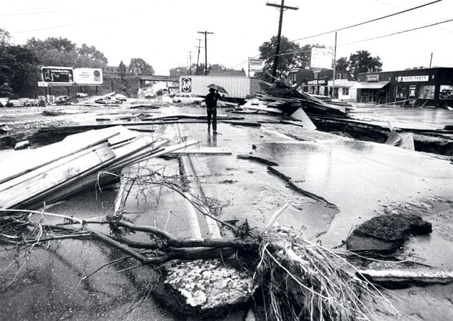
Flash flooding was the first punch. Rain pelted the Washington
area, up to an inch an hour from Wednesday evening through Thursday, June
22. Few streams rose faster than DC’s Rock Creek. At the nearby National
Zoo, director Theodore Reed leapt into the wolf enclosure to save a pup
from drowning.
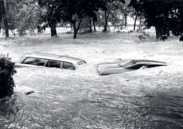
The volume of water cannonballing down Rock Creek was double
that of any storm in recorded history. Motorists by the hundreds along
Rock Creek Parkway, Canal Road, and the Whitehurst Freeway were forced to
run or swim from cars or were trapped inside or swept to their deaths as
water went from hubcap-deep to above windowsill level in
minutes.
In Virginia, the Occoquan River jumped six feet above its dam
and gouged a new channel around one end. Some 1,600 people, the bulk of
them in Prince William County, were made homeless by the flooding, and
thousands more evacuated as streams where toddlers usually splashed
engulfed subdivisions. Most homeowners in 1972 had no flood
insurance.
Outside Baltimore, a young mother in the upscale Ruxton suburb
was blocked by floodwater roaring down the Jones Falls stream valley as
she attempted to evacuate her three children, ages seven months to 3½
years. As she frantically tried to extricate them from their safety seats,
the flood swept her away and filled the car. Rescuers found her later,
still alive and huddled in the branches of a downstream tree. The children
had drowned.
Greater floods were building as the storm cleared out on
Friday, June 23. Agnes had dumped as much as 18 inches of rain in some
places and a foot in many others, but the real story was its scope. Never
in eastern North America had a storm rained so hard across so many
thousands of square miles—enough, it was calculated, to add two feet of
water across the 2,500-square-mile Chesapeake if the bay had been a
reservoir, dammed at the mouth.
On Friday, June 23, reporting on Agnes for the Baltimore
Sun, I got a look at what was headed for Washington as I crawled on
hands and knees along a railroad bridge at Harpers Ferry, West Virginia,
where the Shenandoah River normally slid peaceably, clear and shallow,
into the Potomac. The bridge was vibrating hard enough that I didn’t feel
confident to stand to snap a photo. A loaded coal train had been parked
there in hopes that the weight would help anchor the bridge.
Where the two rivers collided thunderously in angry, brown
foam, they created acres of standing waves several feet high. I had grown
up among watermen on the Chesapeake and recall thinking that the best of
their boats would be made matchsticks in this normally canoeable
spot.
In Washington, the Potomac River crested Saturday, June 24—made
chocolate with topsoil washed from a nearly 15,000-square-mile watershed
and swollen to about twice its normal width. Refrigerators from
Pennsylvania, pieces of turkey houses from West Virginia, caskets from a
local mortician—the quantity and diversity of the debris moving downstream
were remarkable. From the Watergate, the Washington Post noted,
“residents sipped champagne and watched the show.”
Boats torn from moorings littered the shores for miles. Trees,
roots and all, spun in the current. It would turn out that more than
200,000 trees had been ripped from the C&O Canal National Historic
Park alone. With 66 miles of towpath severely damaged, the park would take
years to repair.
Much of DC’s waterfront flooded, including parking lots at
National Airport and the Kennedy Center. Only the coincidence of the
Potomac’s crest with low tide prevented the river from breaking the flood
of 1936’s record.
To the south, a sixth of Richmond—some 200 blocks of the city’s
downtown—was inundated. Flows peaked in the James River on June 23 at 70
times normal. (They were 45 times normal in the Potomac.) Floodwater
crested well above a seawall that had been constructed to protect the
Virginia capital after the 1936 flood.
In Maryland, the Patapsco River ran 12 feet high down Ellicott
City’s historic main street. A warehouse of barrels containing unknown
chemicals and roofing products washed into one of Baltimore’s major
drinking-water reservoirs, mobilizing a days long “fishing” expedition
with every boat that Maryland’s Department of Natural Resources could
muster.
Most attention was riveted, however—and Agnes’s awful power was
most apparent—near the northern Maryland town of Conowingo. There, for
only the second time since it was built in 1928, all 53 floodgates had
been opened at the mammoth, 116-foot hydro dam plugging the Chesapeake’s
mightiest river, the Susquehanna. I had seen water cascading through
Conowingo’s floodgates during lesser storms, but now they disgorged into
the river massive, graceless chunks—“projectile vomiting,” my notes from
that week say.
In normal times, the 464-mile-long Susquehanna, draining lands
as far away as Cooperstown, New York, sends almost as much freshwater to
the Chesapeake as do the rest of the bay’s rivers combined. (The Potomac
is a distant second.) Agnes struck harder in Pennsylvania’s sprawling
Susquehanna basin than anywhere else—the whole state was a federal
disaster area.
On Friday, June 23, a bulletin came from the dam’s operators:
The river was reaching a point where Conowingo’s stability “cannot be
controlled.” The dam was evacuated, with explosives installed to blow out
a section if necessary. People emptied from the Maryland towns of Port
Deposit and Havre de Grace, downstream from the mile-long lake of water
held in check by Conowingo Dam.
Eventual flows peaked above anything seen before or since, but
the dam, anchored in bedrock and thick enough to carry two lanes of US
Route 1 nearly a mile across the river, held. Subsequent surveys showed
that Agnes actually had moved the dam a quarter inch on one side. Route 1
was shut down for months while it was reanchored.
Expert observers at Conowingo had noted that the water
thundering through the floodgates was darkening beyond the solid brown
coming from upstream. That signified a rare occurrence: The river’s force
was so great that it was scouring deep into long-buried, deoxygenated
sediments that had been trapped behind Conowingo Dam for decades. The
scour sent an estimated 20 million tons of smothering, polluting sediment
hurtling downstream—in addition to another 14 million tons washed from
upstream. No other storm has come close.
It was impossible to predict what the impact of such an event
would be on the Chesapeake environment. Such a storm was statistically
unlikely to recur for centuries. With no assurance of funding, scientists
from Maryland and Virginia, along with Johns Hopkins, launched research
cruises in the wake of Agnes, eventually making it the only tropical storm
with its own 600-page book (The Effects of Tropical Storm Agnes on the
Chesapeake Bay Estuarine System,Johns Hopkins Press,
1977).
The researchers knew that, among the world’s coastal
ecosystems, the Chesapeake was almost uniquely sensitive to what occurred
across the lands of its watershed. The reason was partly the sheer size of
the watershed, more than 20 times the acreage of the bay it drained into.
What’s more, there was surprisingly little water in the Chesapeake to
dilute what its rivers sent down. The bay looks big—about a million feet
long and up to a million feet wide—but it’s thin, with an average depth of
about 22 feet.
This shallowness is key to the bay’s historic productivity,
letting enough light penetrate to sustain hundreds of thousands of acres
of rooted aquatic seagrass meadows. These lush grass beds are among the
richest, most productive ecosystems on earth, on a par with coral reefs,
mangroves, rainforests, and wetlands.
The grasses had been torn up by other hurricanes such as Hazel,
Connie, and Diane in the 1950s and had come back quickly. Agnes, whose
unprecedented clouds of sediment shut off vital light during the critical
part of the growing season, devastated the grasses. Six years later, their
baywide acreage was still down by nearly two-thirds. Only in the last
decade or so have they rebounded in the upper Chesapeake and parts of the
Potomac. But across the bay as a whole, they’ve never approached pre-Agnes
levels.
Another Chesapeake icon that Agnes tipped over the edge was the
oyster, whose once-extensive reefs were both a key habitat and a pollution
filter for the estuary. Oysters were already in decline from
overharvesting, but catches in the Potomac River alone still exceeded
600,000 bushels annually before Agnes struck.
It was an unlikely-sounding “pollutant,” the massive thrust of
freshwater from the storm that wiped out many of the Potomac’s rich
shellfish bottoms, according to A.C. Carpenter, executive secretary of the
Potomac River Fisheries Commission. To live, oysters need about five parts
salt per thousand parts water, Carpenter says. Freshwater is zero parts
salt, ocean water about 32.
The Chesapeake, a mixture of ocean and riverflow, normally
maintains tolerable salinities throughout the oysters’ range in the
estuary. But Agnes’s torrents literally shoved the Atlantic Ocean back
dozens of miles, apparently blocking any normal rebound of salt up the
Potomac for several days. In colder weather, the oysters might have
clamped their shells shut and effectively hibernated, but they couldn’t do
that in the warmer June waters.
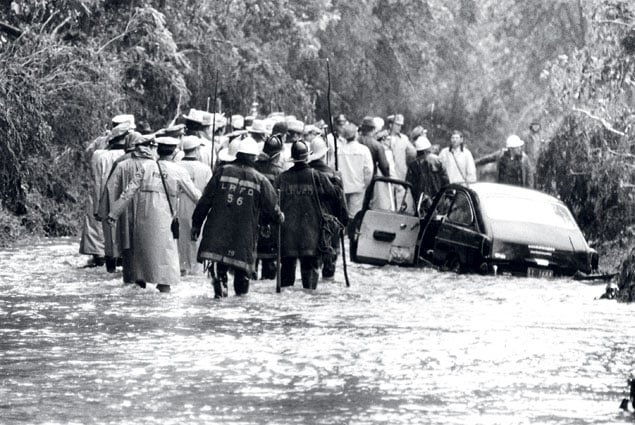
Photograph by Clarence B. Garrett/Baltimore Sun.
A year later, yet another legacy of Agnes emerged to claim most
of the oysters that survived the 1972 onslaught. Large volumes of organic
matter deposited by the floods along the Potomac and Chesapeake bottoms
the previous year caused huge sags in vital aquatic oxygen as bacteria
decomposed them. Despite extensive restoration of oyster bars, Carpenter
says, Potomac harvests never again approached their levels before
Agnes.
In addition, Agnes killed off an estimated 90 percent of the
bay’s lucrative soft-shell clams. Perhaps already stressed by being at the
southern limit of their species’ range here, the clams would rebound from
place to place and time to time, but they never regained their prominence
in watermen’s incomes.
Longtime Maryland Watermen’s Association president Larry Simns
recalls that after riding out the winds and rain of Agnes in his workboat
docked on the Eastern Shore, “I didn’t really see how this one storm could
change my life.” But then, according to his memoir to be published later
this year, Simns began watching “my bay turned to brown gravy . . . dead
cows, drums of chemicals floating by.” The reports of shellfishing
closures began piling up as health authorities acted to prevent
sewage-contaminated clams and oysters from reaching market.
At some point, Simns writes, “I instinctively knew that my own
best fishing days were in the past. . . . My primary job [as Watermen’s
Association president] was going to be to defend the lives and livelihoods
of watermen.”
He continues: “What we hoped was a ‘freak storm’ back then has
become our daily reality today.”
Four decades after Agnes, despite attempts to restore it, the
Chesapeake ecosystem has never regained the overall health it enjoyed
before June 1972.
But we can’t lay all blame on any one storm. We might better
argue that Agnes pulled the trigger, releasing insults that had been
building across the bay’s watershed. Since the 1950s, fertilizer use on
farmland had increased threefold. Animal farming in regions of the bay had
become much more concentrated, resulting in an ever-increasing spreading
of manure.
An excess of such nutrients is now recognized as the bay’s
single biggest pollution problem. But why hadn’t it affected the body of
water more before Agnes? Consider that just as the bay is hugely impacted
by storm water carrying pollution off its watershed, in dry times a lot of
that pollution remains stored in soil and groundwater.
And dry it had been, with river inflows to the Chesapeake below
average every year from the mid-1950s until the early ’70s, including a
period of such drought in the ’60s that some feared the Washington region
would run out of drinking water. In effect, says J. Court Stevenson, a bay
researcher with the University of Maryland, “we may have just been saving
up all those pollutants to be flushed out into the bay.”
Stevenson’s work in the late 1970s led to understanding how
runoff of nutrients and sediment was harming the seagrasses. And even
without Agnes, the ’70s was a decade of relatively high runoff to the
bay.
Add to all this a population in the Chesapeake watershed that’s
on its way to doubling from 8 million in the 1950s to 17 million today, in
the process dramatically increasing sewage flows. The population growth
has also led to continued paving and development as well as to the
clearing of forests and the filling of wetlands; forests and wetlands are
both excellent buffers against polluted runoff. Then throw in oyster
diseases that grew worse after Agnes (but may not be directly related to
it), continued overfishing of some species of sea life, and warming bay
temperatures that appear to be keeping some species of aquatic grasses
scarce.
We can blame Agnes for a lot, but Maryland Watermen’s
Association president Larry Simns laments that much of today’s grim
reality can be traced to the manifold ways the burgeoning population
continues to pollute.
Says Jerry Schubel, the top bay scientist who was an organizer
of the research cruises immediately following Agnes: “Perhaps we focus too
much on the big events and not enough on all the chronic stresses, the
damage we do every day.”
Schubel, now head of the Aquarium of the Pacific in Long Beach,
California, says he has tried to make the same point about the Gulf of
Mexico, which suffers, he says, more from all the pollution flowing daily
down the Mississippi River than from the BP oil spill in 2010.
The influx of freshwater to the Chesapeake from Agnes did have
a salutary effect for humans: It virtually wiped out the bay’s normally
robust population of stinging sea nettles and depressed their reproduction
for two years afterward.
Agnes lent humbling perspective to a writer hired by the
Baltimore Sun just before the storm blew in. Now, after 40 years
of covering the Chesapeake, I suspect my biggest story happened the first
few weeks on the job, when I was too green even to get a
byline.
On a scientific level, Agnes taught me how “episodic”
events—occurring on the order of centuries or longer—can be as critical to
understanding nature as day-in, day-out observation. A scientist can
measure sediment flowing to the bay through a whole career, for example,
and have the illusion he knows how such flows worked—until an Agnes comes
along.
And just how unusual a storm was Agnes? I’ve heard it called
everything from a “hundred-year storm”—referring to a magnitude that has a
1-percent chance of occurring in any year—up to a 500-year storm. The real
problem is that we don’t have the thousands of years of data needed to put
such rare events as Agnes in proper perspective. In addition, the
timing—June—may have been more unusual and damaging than the rainfall
volumes.
Quite literally, we’ll never see another Agnes. The National
Weather Service retired the name along with those of 75 of the nation’s
other most costly and deadly storms.
Tom Horton (swanfall@gmail.com) began covering the Chesapeake Bay for the Baltimore Sun in May 1972, and the assignment lasted through 2006. He now writes columns for the monthly Bay Journal and teaches writing and environmental studies at Salisbury University. Horton is the author of eight books on the Chesapeake.
This article appears in the June 2012 issue of The Washingtonian.