This year will be remembered for giving Washington many anxieties, but perhaps none was as much of a throwback as the lurking specter of Russia. Moscow’s meddling goes back decades, but who ever knew the Kremlin’s interest in DC was once so intense as to keep track of cemetery footpaths, water depths, and golf-course layouts?
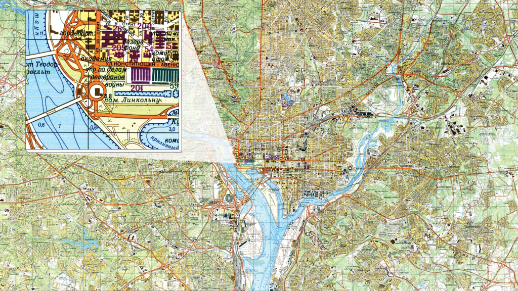
Those obscure details—and more—are featured in this 1975 map of Washington produced by the Soviet Union’s Chief Administration of Geodesy and Cartography, a program under the USSR’s Ministry of Internal Affairs that attempted to map cities all over the world with such detail as to include their buildings. The result was part invasion map, part occupation guide, and part encyclopedia, a generation before anything as convenient as Google Earth. USSR mapmakers painstakingly recorded details most Washingtonians probably didn’t consider about their region, such as places to dock a ship and the construction materials of roads.
Once closely guarded, the maps made their way west with the fall of the USSR. The Washington edition was provided to me by John Davies, an English collector who learned of the Soviet map program in the early 2000s and maintains a comprehensive website on the subject.
Much of the fieldwork was done by Soviet Embassy employees in the early 1950s. Military installations that appear as blank spaces on publicly available US maps, such as the Naval Surface Warfare Center in Bethesda, are included. So are Washington’s reservoirs and pumping stations, many of which are hidden underground.
Even though the maps were constructed in the service of Soviet ambitions, the reconnaissance behind them was technically legal. Embassy employees freely roamed the city, buying armloads of aerial photos, technical magazines, and patents from the US Patent Office. It wasn’t until 1955 that the State Department placed restrictions on photographs the embassy was allowed to gather.
But for all the attempts at detail, the map contains plenty of tiny errors. Blue notches on the riverbanks indicate spots suitable for mooring a ship. Surprisingly, the mapmakers used these markings in some places where mooring a ship clearly wasn’t an option, such as the Tidal Basin and even the Reflecting Pool.
Still, the maps are a fascinating snapshot into a different era of Washington’s history: The pre–Kennedy Center waterfront in Foggy Bottom is dominated by the Heurich Brewing Company’s enormous plant, torn down in 1962. And those structures just north of the Reflecting Pool, where Constitution Gardens now sits? Those were the Main Navy and Munitions Buildings, constructed in 1918 and torn down in 1970.
This article appears in the December 2016 issue of Washingtonian.

